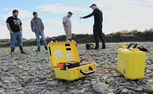
Mathias Vang (right) of Denmark’s Aarhaus University discusses the APSU surface nuclear magnetic resonance system with (from left) Lincoln Agritech’s Blair Miller, Shaun Kingsbury, and Scott Wilson.
New Zealand’s braided rivers dominate our east coast environments. But how do they affect the amount of water that’s in our aquifers, and available for human activity and nature? And how do we find out?
Until recently, no one knew how they worked beneath the surface and interacted with our aquifers. But with a lot of technology and perseverance we are now beginning to find the answers.
Lincoln Agritech’s Scott Wilson is leading a five-year project, funded by the Ministry of Business, Innovation & Employment to find out just how braided rivers and regional aquifers interact, to store and transport water.
Now halfway through the project, Scott and his team have already made some interesting discoveries, used a lot of technology in novel ways, and had two big setbacks when “one-in-200-year” floods washed away a lot of their equipment on the Selwyn-Waikirikiri and Wairau rivers.
“We lost quite a bit of our equipment on those rivers in 2021,” says Scott. “However, we had already captured some data, so we replaced the equipment and carried on. And it actually gave us an opportunity to study what was essentially a new river in each case, as they had both changed so much.”
The equipment they’re using includes a totally novel use of fibre optic cables installed horizontally under the rivers to help analyse river-groundwater exchange under different flow conditions
It also includes equipment never used before in New Zealand such as an APSU surface nuclear magnetic resonance system, which measures the porosity and water content of sediment non-invasively (and so doesn’t alter water flow through the very act of measuring).
That particular piece of equipment had to be imported into New Zealand, along with its specialist operator Mathias Vang from Aarhus University in Denmark. With COVID immigration restrictions, this was yet another obstacle to be overcome.
The team has also used tTEM – an electromagnetic system that is dragged along the ground to produce detailed 3D geophysical and geological maps of the sub-surface – satellite imagery combined with flow recorders to accurately measure river losses, and radon tracing to measure river water loss.
“Because we are studying something that’s never been studied before, we are applying methods that have never been used in New Zealand before,” says Scott.
Those methods are paying dividends.
“We now know how braided rivers work in the sub-surface. We know specifically what controls the amount of water that leaks into the ground water – in other words, what controls how much our rivers recharge the regional aquifers.”
The team has discovered the four important variables that determine just how much water flows from the rivers into the aquifers. They are:
- How much water can be stored in the riverbed gravels
- How easily water flows outwards from the riverbed gravels (lateral permeability)
- How easily water flows downwards in the sediments beneath the riverbed gravels (vertical permeability)
- The river level.
“Now that we know these are the four variables, we can use mathematics and modelling to quantify the effects they have,” says Scott. “And once we’ve done that, we’re in a position to do some scenario analysis to see what effect different river management techniques have on the braided river environment.”
That work is still to be done, but as changing climate and human activity make sustainable water management crucial, this research will help New Zealand councils quantify the environmental and economic benefits of different river management strategies.
“This will be an important step in helping councils meet the Government’s National Policy Statement on Freshwater Management, and ensuring that competing needs for water can be met in the best way possible,” says Scott.
This work is also receiving funding from Environment Canterbury (ECan), Marlborough District Council and Hawkes Bay Regional Council.
Research partners include Lincoln University, the University of Canterbury, Ngāti Kahungunu Iwi Incorporated, Niwa, Flinders University, Technische Universitat Dresden, and Aarhus University.