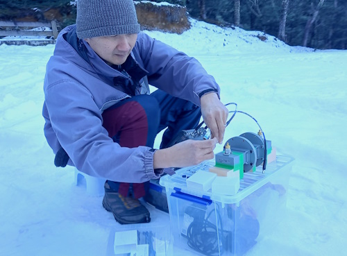
Adrian spent time at Cass, manually measuring snow depth and determining the specifications of an accurate radar for that environment.
Could drone-mounted radar be the key to accurately identifying avalanche risk above alpine roads?
A multi-disciplinary team of scientists and engineers from the University of Canterbury and Lincoln Agritech believe the answer is yes. And their concept has won them third prize in the recent Christchurch Aerospace Challenge.
Lincoln Agritech research scientist Adrian Tan is part of the team that has been developing a three-part device to measure the thickness of sea ice beneath the polar snow packs.
“We were aware that the polar applications are very specific,” says team leader Assoc Prof Wolfgang Rack of the University of Canterbury. “We started discussing how we could extend that to a wider capability.”
Wolfgang contacted Heather Purdie, a glaciologist from the University of Canterbury, who immediately recognised that the technology they were developing for Antarctica could have useful applications in the Southern Alps.
They came up with a plan to develop a lightweight snow radar mounted on a drone that could measure, for example, how much snow was on a slope above a ski field access road, and therefore determine the avalanche risk. But first they had to find out what type of snow they were dealing with.
“Snow looks the same – it’s always white – but it’s very different in the Southern Alps,” says Wolfgang. Wetness, grain size, and density can vary significantly between locations, and New Zealand snow is very wet snow. This affects the accuracy of radar measurement.
With the $10,000 prize for being a finalist in the Christchurch Aerospace Challenge, Adrian was able to spend time at Cass over winter, manually measuring snow depth and determining the specifications of an accurate radar for that environment.
“Radar penetration depth decreases as the wetness of the snow increases,” Adrian says. However, he determined that on drier alpine snow, a radar could easily measure a snow depth of 1 m, while on wetter snow it could measure between 0.5 m and 1 m.
Wolfgang sees the ability to measure avalanche risk as the technology’s main benefit – not just for ski fields, but also, for example, on the Milford Road or alpine passes. But it could also provide another benefit to ski field operators – measuring the depth of snow on their slopes relatively quickly and without the need for multiple manual measurements.
Having proved that the technology could be adapted to the Southern Alps, the team is looking for prospective partners to help develop it further. “It helps that there has been a lot of development in drone technology in the past 10 years,” says Wolfgang.
See also: Marsden award to study sea ice and climate change